|
|
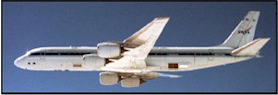
A
Flying Laboratory
AIRSAR instrument
(panels behind wing) mounted aboard a modified NASA DC-8 aircraft. During
data collection, the plane flew at 8 kilometers over the average
terrain height at a velocity of 215
meters per second.
The Airborne Synthetic Aperture Radar (AIRSAR) was an all-weather imaging
tool able to penetrate through clouds and collect data at night. The
longer wavelengths could also penetrate into the forest canopy and in
extremely dry areas, through thin sand cover and dry snow pack.
AIRSAR was designed and built by the Jet Propulsion Laboratory (JPL) which
also manages the AIRSAR project. AIRSAR served as a NASA radar technology testbed for demonstrating new
radar technology and acquiring data for the development of radar
processing techniques and applications. As part of NASA’s
Earth Science Enterprise, AIRSAR first flew in 1988, and flew its last mission in 2004.
Please visit the UAVSAR website for more information about JPL's lastest airborne synthetic aperture radar.
Privacy/Copyright Notice
|
|