An imaging radar works very like a flash camera in that it provides its own light to illuminate an area on the ground and take a snapshot picture, but at radio wavelengths. A flash camera sends out a pulse of light (the flash) and records on film the light that is reflected back at it through the camera lens. Instead of a camera lens and film, a radar uses an antenna and digital computer tapes to record its images. In a radar image, one can see only the light that was reflected back towards the radar antenna.
A typical radar (RAdio Detection and Ranging) measures the strength and round-trip time of the microwave signals that are emitted by a radar antenna and reflected off a distant surface or object. The radar antenna alternately transmits and receives pulses at particular microwave wavelengths (in the range 1 cm to 1 m, which corresponds to a frequency range of about 300 MHz to 30 GHz) and polarizations (waves polarized in a single vertical or horizontal plane). For an imaging radar system, about 1500 high- power pulses per second are transmitted toward the target or imaging area, with each pulse having a pulse duration (pulse width) of typically 10-50 microseconds (us). The pulse normally covers a small band of frequencies, centered on the frequency selected for the radar. Typical bandwidths for an imaging radar are in the range 10 to 200 MHz. At the Earth's surface, the energy in the radar pulse is scattered in all directions, with some reflected back toward the antenna. Thisbackscatter returns to the radar as a weaker radar echo and is received by the antenna in a specific polarization (horizontal or vertical, not necessarily the same as the transmitted pulse). These echoes are converted to digital data and passed to a data recorder for later processing and display as an image. Given that the radar pulse travels at the speed of light, it is relatively straightforward to use the measured time for the roundtrip of a particular pulse to calculate the distance or range to the reflecting object. The chosen pulse bandwidth determines the resolution in the range (cross-track) direction. Higher bandwidth means finer resolution in this dimension.
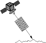
Radar transmits a pulse Measures reflected echo (backscatter )
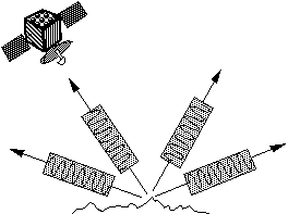
In the case of imaging radar, the radar moves along a flight path and the area illuminated by the radar, or footprint, is moved along the surface in a swath, building the image as it does so.
Building up a radar image using the motion of the platform
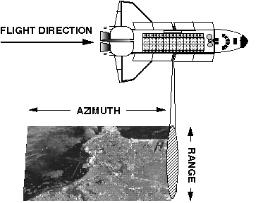
The length of the radar antenna determines the resolution in the azimuth (along-track) direction of the image: the longer the antenna, the finer the resolution in this dimension. Synthetic Aperture Radar (SAR) refers to a technique used to synthesize a very long antenna by combining signals (echoes) received by the radar as it moves along its flight track. Aperture means the opening used to collect the reflected energy that is used to form an image. In the case of a camera, this would be the shutter opening; for radar it is the antenna. A synthetic aperture is constructed by moving a real aperture or antenna through a series of positions along the flight track.
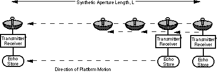
Constructing a Synthetic Aperture
As the radar moves, a pulse is transmitted at each position; the return echoes pass through the receiver and are recorded in an 'echo store.' Because the radar is moving relative to the ground, the returned echoes are Doppler-shifted (negatively as the radar approaches a target; positively as it moves away). Comparing the Doppler-shifted frequencies to a reference frequency allows many returned signals to be "focused" on a single point, effectively increasing the length of the antenna that is imaging that particular point. This focusing operation, commonly known as SAR processing, is now done digitally on fast computer systems. The trick in SAR processing is to correctly match the variation in Doppler frequency for each point in the image: this requires very precise knowledge of the relative motion between the platform and the imaged objects (which is the cause of the Doppler variation in the first place).
Synthetic aperture radar is now a mature technique used to generate radar images in which fine detail can be resolved. SARs provide unique capabilities as an imaging tool. Because they provide their own illumination (the radar pulses), they can image at any time of day or night, regardless of sun illumination. And because the radar wavelengths are much longer than those of visible or infrared light, SARs can also "see" through cloudy and dusty conditions that visible and infrared instruments cannot.
What is a radar image?
Radar images are composed of many dots, or picture elements. Each pixel (picture element) in the radar image represents the radar backscatter for that area on the ground: darker areas in the image represent low backscatter, brighter areas represent high backscatter. Bright features mean that a large fraction of the radar energy was reflected back to the radar, while dark features imply that very little energy was reflected. Backscatter for a target area at a particular wavelength will vary for a variety of conditions: size of the scatterers in the target area, moisture content of the target area, polarization of the pulses, and observation angles. Backscatter will also differ when different wavelengths are used.
Scientists measure backscatter, also known as radar cross section, in units of area (such as square meters). The backscatter is often related to the size of an object, with objects approximately the size of the wavelength (or larger) appearing bright (i.e. rough) and objects smaller than the wavelength appearing dark (i.e. smooth). Radar scientists typically use a measure of backscatter called normalized radar cross section, which is independent of the image resolution or pixel size. Normalized radar cross section (sigma0.) is measured in decibels (dB). Typical values of sigma0. for natural surfaces range from +5dB (very bright) to -40dB (very dark).
A useful rule-of-thumb in analyzing radar images is that the higher or brighter the backscatter on the image, the rougher the surface being imaged. Flat surfaces that reflect little or no microwave energy back towards the radar will always appear dark in radar images. Vegetation is usually moderately rough on the scale of most radar wavelengths and appears as grey or light grey in a radar image. Surfaces inclined towards the radar will have a stronger backscatter than surfaces which slope away from the radar and will tend to appear brighter in a radar image. Some areas not illuminated by the radar, like the back slope of mountains, are in shadow, and will appear dark. When city streets or buildings are lined up in such a way that the incoming radar pulses are able to bounce off the streets and then bounce again off the buildings (called a double- bounce) and directly back towards the radar they appear very bright (white) in radar images. Roads and freeways are flat surfaces so appear dark. Buildings which do not line up so that the radar pulses are reflected straight back will appear light grey, like very rough surfaces.
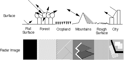
Imaging different types of surface with radar
Backscatter is also sensitive to the target's electrical properties, including water content. Wetter objects will appear bright, and drier targets will appear dark. The exception to this is a smooth body of water, which will act as a flat surface and reflect incoming pulses away from a target; these bodies will appear dark.
Backscatter will also vary depending on the use of different polarization. Some SARs can transmit pulses in either horizontal (H) or vertical (V) polarization and receive in either H or V, with the resultant combinations of HH (Horizontal transmit, Horizontal receive), VV, HV, or VH. Additionally, some SARs can measure the phase of the incoming pulse (one wavelength = 2pi in phase) and therefore measure the phase difference (in degrees) in the return of the HH and VV signals. This difference can be thought of as a difference in the roundtrip times of HH and VV signals and is frequently the result of structural characteristics of the scatterers. These SARs can also measure the correlation coefficient for the HH and VV returns, which can be considered as a measure of how alike (between 0/not alike and 1/alike) the HH and VV scatterers are.
Different observations angles also affect backscatter. Track angle will affect backscatter from very linear features: urban areas, fences, rows of crops, ocean waves, fault lines. The angle of the radar wave at the Earth's surface (called the incidence angle) will also cause a variation in the backscatter: low incidence angles (perpendicular to the surface) will result in high backscatter; backscatter will decrease with increasing incidence angles.
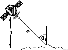
Radar backscatter is a function of incidence angle, (theta)i
NASA/JPL's Radar Program
NASA/JPL's radar program began with the SEASAT synthetic aperture radar (SAR) in 1978. SEASAT was a single frequency (L-band with lambda ~ 24 cm or 9.4 inches), single polarization, fixed-look angle radar. The Shuttle Imaging Radar-A (SIR-A), flown on the Space Shuttle in 1981, was also an L- band radar with a fixed look angle. SIR-B (1984) added a multi-look angle capability to the L-band, single polarization radar. SIR-C/X-SAR is a joint venture of NASA, the German Space Agency (DARA), and the Italian Space Agency (ASI). SIR-C/X-SAR provided increased capability over Seasat, SIR-A, and SIR-B by acquiring images at three microwave wavelengths (lambda), L- band (lambda ~ 24 cm or 9.4 inches) quad-polarization; C-band (lambda ~ 6 cm or 2.4 inches) quad- polarization; and X-band (lambda ~ 3 cm) with VV polarization. SIR-C/X-SAR also has a variable look angle, and can image at incidence angles between 20 and 65 degrees. SIR-C/X-SAR flew on the shuttle in April and in October of 1994, providing radar data for two seasons. Typical image sizes for SIR-C data products are 50kmx100km, with resolution between10 and 25 meters in both dimensions.
Parallel to the development of spaceborne imaging radars, NASA/JPL have built and operated a series of airborne imaging radar systems. NASA/JPL currently maintain and operate an airborne SAR system, known as AIRSAR/TOPSAR, which flies on a NASA DC-8 jet. In one mode of operation, this system is capable of simultaneously collecting all four polarizations (HH,HV, VH and VV) for three frequencies: L- band (lambda ~ 24 cm); C-band (lambda ~ 6 cm) ; and P-band (lambda ~ 68 cm). In another mode of operation, the AIRSAR/TOPSAR system collects all four polarizations (HH,HV, VH and VV) for two frequencies: L- band (lambda ~ 24 cm); and P-band (lambda ~ 68 cm), while operating as an interferometer at C-band to simultaneously generate topographic height data. AIRSAR/TOPSAR also has an along-track interferometer mode which is used to measure current speeds. Typical image sizes for AIRSAR/TOPSAR products are 12kmx12km, with 10 meter resolution in both dimensions. Topographic map products generated by the TOPSAR system have been shown to have a height accuracy of1 m in relatively flat areas, and 5 m height accuracy in mountainous areas.
JPL are studying designs for a free-flying multi- parameter imaging radar system like the one flown during the SIR-C/X-SAR missions. JPL are also studying a global mapping mission (TOPSAT) which will use radar interferometry to generate high quality topographic maps over the whole world and monitor changes in topography in areas prone to earthquakes and volcanic activity.
To inquire about the availability of imaging radar data from the SIR-C, SIR-B, SIR-A or Seasat missions, or the airborne AIRSAR/TOPSAR system, please contact:
Radar Data Center
Mail Stop 300 - 233
Jet Propulsion Laboratory
4800 Oak Grove Drive
Pasadena, CA 91109
Fax: (818) 393 2640
e-mail: radar.data@jpl.nasa.gov
To learn more about NASA/JPL's Imaging Radar Program, if you are an Internet user, please refer to World Wide Web server site at URL: http://southport.jpl.nasa.gov/