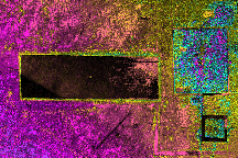
Dense ancient and modern development at the heart of Angkor
is shown on
this airborne radar image collected in late 1996.
Two temple complexes
are shown on the image: Angkor Wat (lower right) constructed
in the
11th century and Angkor Thom, built in the 9th century
(upper right).
Extensive water management structures are also shown
including square
moats surrounding the temples and the large rectangular
reservoir or
baray seen in the left of the image; this baray is 8
km long. The dark
line (lower center) is the Siem Reap airport runway,
which provides
tourist access to these ancient monuments. Topographic
height
information is shown in color with one color cycle (yellow
to yellow)
representing 20 m of elevation change. This information
is overlain on
a radar image of the area. The data were collected
by JPL's airborne
radar system, AIRSAR. (P-49960)