
NEWS & INFORMATION
FY 2002 EARTH SCIENCE ENTERPRISE SUBORBITAL SCIENCE FLIGHT PROGRAM
AnnouncementRelease Date: April 2, 2001 Due Date: June 1, 2001
The National Aeronautics and Space Administration (NASA) Earth Science Enterprise announces the release of a "Call Letter" for the 2002 Suborbital Science Flight Program in support of the Office of Earth Science (OES). The purpose of the announcement is to solicit flight requests for remote or in-situ sensing by Principal Investigators requiring an aircraft platform. The sensors may be furnished as NASA "core" sensors or supplied by the Principal Investigator. Participation is open to all categories of organizations: NASA centers, other Government agencies, educational institutions, and nonprofit organizations. Flight requests may be submitted from April 2 - June 1, 2001 for initial flight season planning.
The call letter with complete instructions will be available electronically on April 2, 2000 via the Internet at the NASA Airborne Science Program Home Page: http://www.dfrc.nasa.gov/airsci. General information about the ESE Suborbital Science Program is available at http://www.earth.nasa.gov/science/suborbital.
Paper copies of the Flight Request will be available to those who do not have access to the Internet by faxing a message to (661) 258-3719 requesting a flight request form. Please provide your full name and address, including zip code, and your telephone and fax number, including area code.
Questions regarding this announcement can be addressed to NASA Headquarters, Code YS, Washington, DC 20546, Attn.: Cheryl Yuhas, telephone number (202) 358-0758 (-2770 FAX), E-mail: cyuhas@hq.nasa.gov or to NASA Dryden Flight Research Center, M/S 1623H, P.O. Box 273, Edwards, CA 93523-0273, Attn.: Randy Albertson, telephone number (661) 258-7540 (-3719 FAX), E-mail: randy.albertson@dfrc.nasa.gov.
2001 Update - January 2, 2001
There will be no AIRSAR data flights during the 2001 calendar year.
This is due to the long PacRim 2000 deployment that occurred at the
end of fiscal year 2000 and the beginning of fiscal year 2001.
During PacRim 2000, over 60 hours of AIRSAR data were collected and
2001 will be largely devoted to the processing of these data. In
addition, we are looking at making some upgrades to the AIRSAR
instrument hardware, much of which has not been replaced since the
system was built in 1985.Flight requests submitted for the 2001 calendar year will be deferred
to 2002 when we will try to accomplish as many of them as possible.
The flight schedule for 2002 is posted at the NASA Dryden web site
(http://www.dfrc.nasa.gov/airsci/dc85yr.html) although updates to
this schedule can occur on a frequent basis. The tentative plan for
2002 is a US deployment in the midwest in the March-April timeframe,
with a possible deployment to Central and South America later in the
year. We will use this space to keep the community informed of any
changes as they occur.The map shows the sites for the pacrim missions.
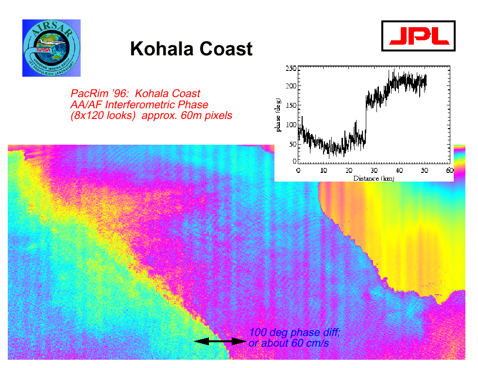
Along-Track Interferometry (ATI) Experimental Dataset Released
An ATI dataset collected over the Kohala coast of the big island of Hawaii has been processed and is available for evaluation. Additional ATI datasets will be generated during the next several months.
These are large data files; the experimental dataset is distributed on 6 CD-ROMs. Copies of this dataset can be requested via email to: ellen.oleary@jpl.nasa.gov